Weetangera Road web-links
Canberra, Australia, 2019.
.
.
.
.
.
This is your portal to a list of hyperlinks (URLs or web-links) to other online web pages that have interesting information about the history and heritage of the Weetangera Road and Flea Bog Flat. Scroll down for a descriptive list of web links.
Dave Parsons
About Weetangera Road
The Weetangera Road became a Parish Road linking North Canberra, in Australia's Capital City, with the confluence of the Molonglo and Murrumbidgee Rivers.
It originally was in the State of New South Wales (NSW), in an area that in the early 1900s became the Australian Capital Territory (ACT).
At its longest, it ran mainly east-west for nearly 20km, from what became the ACT suburb of Lyneham, to Uriarra Crossing on the Murrumbidgee River.
Most of it provided the dirt access road to rural properties in the Weetangera Parish, NSW, in the mid1800s to late 1960s, after most of the land had been incorporated into the ACT.
In 1966, it provided access to the first suburban development in the District of Belconnen, ACT. That development obliterated much of the Weetangera Road.
Remnant parts of Weetangera Road are still in use though, such as:
- most of Stockdill Drive, West Belconnen;
- the cycleway over Bruce Ridge from Dryandra Street, O'Connor, to Canberra's Stadium;
- the segment of the Canberra Centennial Trail between Purdie Street, at the Canberra Institute of Technology, Bruce (Bruce CIT), and Masterman Street at the Australian Institute of Sport (AIS) / Stadium precinct; and
- the walking track through bushland from near the corner of Haydon Drive and Jaeger Circuit Bruce to Belconnen Way.
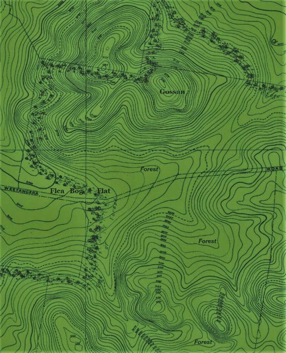
That bushland walking track includes a former section of Weetangera Road that lead into Flea Bog Flat...an often boggy area south of Gossan Hill, in the suburb of Bruce.
Links to online historical information
20 000+ years of people in the Belconnen area:
The knowledge holders spoke of how the lower Ginninderra Creek was connected to the surrounding cultural landscape through a network of pathways and songlines...Tyrone Bell spoke of how the Ginninderra Falls (Place 1) area was connected to Black Mountain, lying to the southeast, as part of the ceremonial process for young men’s initiation...One area Dad spoke about was Black Mountain, did business up there and then came down into Ginninderra, the preparation was at Black Mountain and then on to Ginninderra and that connection to the water.
Richie Allen spoke of the songlines and pathways that connected the Ginninderra Falls area to Lake George in the northeast, to Black Mountain and Tuggeranong to the south, and across the Murrumbidgee River to Tidbinbilla to the south west. The songlines and pathways go from the Falls area to Gungahlin and out to Lake George and Black Mountain. They did women’s business and young men’s business at the Falls and then they travelled to Black Mountain and then separated onto different paths for the men and the women elders to travel up to Tuggeranong...
Tyrone referred more broadly to the way the young men prior to initiation are moved from the care of the women to that of the senior men,... His understanding is that this process of shifting the young men from the women’s to the men’s domain began at Black Mountain prior to traveling down the pathway to the Ginninderra Falls. [It may be that sections of the pathways connecting Black Mountain and the lower Ginniderra Creek were a predecessor to part of the much later Weetangera Road corridor of travel, particularly by non-aboriginal settlers and their families and laborers around the mid 1800s. Weetangera Road cuts across a saddle in the ridge running from Black Mountain to O'Connor ridge, less than 2km north of Black Mountain, 700m from the edge of Black Mountain nature reserve. It is a natural low point that makes an easier, and least steep pathway over the ridge. ] :
https://ginninderry.com/wp-content/uploads/2016/09/UPDATED-REDACTED-PUBLIC-Ginninderry-Final-Cultural-Values-Assessment-Report-v.2.compressed.pdf pages 80-81.
In the Canberra area Aboriginal people are recorded as harvesting a wide range of foodstuffs. ‘Greater Black Mountain’ would have provided kangaroos, wallabies, bandicoots, wombats, possums, native cats (quolls), pigeons, turkeys, eggs, snakes and lizards, grubs and insects, grass seed, tuberous roots and yams, berries, gum, nectar and honey, while plains and adjacent streams provided platypus, waterfowl, emus, brolgas, fish and shellfish. (Wright 1923:59; Watson 1927:14; Bluett 1954:6; Kabaila 1997; Jackson-Nakano 2007; GML 2013). :
https://www.friendsofblackmountain.org.au/sites/default/files/Symposium2018/19-Butz-Cult-landscapes-Final-20Dec18.pdf page 382.
Aboriginal communities inhabited the Canberra region during the Ice Age, otherwise known as the Pleistocene Epoch. To date, the most well known research work on Aboriginal people in the ACT is that of Josephine Flood in 'The moth hunters: Aboriginal prehistory of the Australian Alps' (1980). Flood suggests that Aboriginal people have been visiting the ACT and surrounding tablelands for over 20,000 years. :
https://www.environment.act.gov.au/heritage/heritage-in-the-act#aboriginal
...excavations carried out in 2008, prior to suburban development, unearthed one of the richest and densest Aboriginal artefact sites within the ACT. The greatest number of artefacts was found nearby on the banks of Ginninderra Creek. This is consistent with other findings where the main Aboriginal activity is close to waterways...The artefacts found here include flakes, blade cores and waste flakes representing the manufacture of tools. Aboriginal people camped, hunted and collected materials throughout the landscape. : https://www.canberratracks.act.gov.au/heritage-trails/track-6-belconnen/west-macgregor
Gossan Hill is also located on a possible Aboriginal pathway. Although protracted geological testing has erased direct evidence of past Aboriginal exploitation of the ochre there are still many Aboriginal artefacts to be found on the ridges, peaks and saddle of Gossan Hill. Prior to European settlement, Aboriginal people lived in the Canberra region for many thousands of years and the existence of stone artefacts on Gossan Hill confirms that Aboriginal people had used the site in the past. Kabaila (1994) notes finding some ochre at a site in the suburb of Aranda at the northwest foothills of Black Mountain, which would support the idea of ochre transport along pathways, however the veracity of this ochre’s origin is yet to be proven. Gossan Hill is part of an Aboriginal pathway that runs to the northeast following a low ridge system towards Gubur Dhaura, another ochre source and known Aboriginal site. It is also noteworthy that the pathway crosses another large site with a minor ochre source located in Crace. [Flea Bog Flat, and part of Weetangera Road, were at the southern foot of Gossan Hill. Gubur Dhaura Nature Park is off Manning Clark Crescent, Franklin ACT]. :
https://www.environment.act.gov.au/__data/assets/pdf_file/0011/737435/Background-Information-Gossan-Hill-ENDORSED-HCM-20150604.pdf page 2.
1800s: Settlement and pioneering:
1820
In late1820, Charles Throsby Smith, James Vaughan and Joseph Wild crossed from Lake George with two aboriginal guides and camped on the Molonglo River near Pialligo on 7 December of that year (Brown2014). The following day they climbed Black Mountain in their quest to find new grazing lands for a rapidly increasing colonial population. They saw the landscape “...formed part of a stretch of magnificent country thickly peopled by an aboriginal tribe, because of its abundance of natural food supply” (Gale1927). : https://www.friendsofblackmountain.org.au/sites/default/files/Symposium2018/01-Finlayson-BM-geology-Final-20Dec18.pdf page 2.
1820s+
European settlement of Canberra during the 19th and early 20th centuries can be divided into two main cultural phases:
1. The initial European settlement of Canberra (1820-1850) after European exploration of the Limestone Plains and the Murrumbidgee River and subsequent establishment of permanent occupation of the region; and
2. The consolidation period (1850-1911) commencing in the 1850s during the gold rush period and the introduction of Robertson’s Land Acts in the 1860s.
European interest in the Limestone Plains began in the 1820s...Early European settlement in the ACT [then still NSW] was established through the acquisition of land grants and the practice of squatting...During this early phase, life was difficult...The infrastructure was poor; there were no roads or rail services...By the mid 1830s, the conditions improved, as postal services were established in Queanbeyan, the urban centre of the Limestone Plains [later the Limestone Plains became better known as Canberra, see mentions of 'Limestone Plains' near Queanbeyan, and no mention of Canberra on the 1886 NSW maps at: https://nla.gov.au/nla.obj-231052850/view and https://nla.gov.au/nla.obj-231327228/view ]. Settlement of Canberra continued to consolidate as gold was discovered east of Queanbeyan in the 1850s...In 1861, the NSW Lands Minister introduced the Crowns Lands Alienation Act and the Crown Lands Occupation Act, collectively known as the Robertson Land Acts or Free Selection Acts. These Acts allowed that any individual to choose a block of Crown Land between 40 and 320 acres at a fixed price of £1 per acre. The purchase conditions required minimum improvements within a three year period. [This "free selection" process had the desired effect of incresing the number of farmers residing in rural areas such as the Weetangera Parish (predecessor of much of Belconnen District). It is possible that by the early 1860s, informal paths of indigenous people, and of horses, carts and of livestock droving tracks had began to consolidate, giving birth to what became the Weetangera Road]. : https://www.environment.act.gov.au/__data/assets/pdf_file/0018/1034460/Background-Information-Old-Lands-End,-Belconnen.pdf
1823
The first Europeans on the Limestone Plains were employees of JJ Moore, who grazed sheep in 1823 at ‘Canberry’ (now Acton) (Fitzgerald 1987:12). :
https://www.friendsofblackmountain.org.au/sites/default/files/Symposium2018/19-Butz-Cult-landscapes-Final-20Dec18.pdf page 383.
1825
Interactive map, which can display a range of historic plans of the now ACT area, from 1825 to 1943, superimposing layers of modern aerial photography or road reserve and block and section boundaries. Excellent for locating Weetangera Road's historical locations in the modern landscape. : http://www.actmapi.act.gov.au select Historic Plans. 1955 aerial photography is also available by selecting Aerial Imagery.
1830
The Old Weetangera Road is one of the oldest trackways in the Canberra district, and has had a long and colourful life....It was first referenced in the 1830s, soon after European occupation of the area, but it is likely that the route was first used thousands of years before. It follows the flat ground and low saddles between the Canberra Plain and the Murrumbidgee River, and linked up to other tracks across the river to give access to towns such as Tumut. : https://www.actionheritage.com.au/uploads/1/1/7/6/117696695/old_weetangera_road_trail_notes.pdf
1831
First pioneer farmer near the Belconnen area (west of Black Mountain): Alick] Osborne, a ship’s surgeon, bought Portion 35 of 987 acres, Parish of Wallaroo in 1831, for 5/- an acre. In 1854 it cost Thomas ₤1,500 (or 30/- an acre). Upon his death in 1881, he passed it to the four sons of his first marriage who had helped him build a thriving farm, home, and carrying business - Thomas, Samson, Samuel and John. Subsequently it became a Kilby family home. With good frontage on Ginninderra Creek, just above the Ginninderra Falls, Parkwood fell outside the Federal Capital Territory when it was proclaimed in 1909.: https://museum.hall.act.au/display/1939/person/2245/thomas-southwell.html
1832
Definition of these parcels of property was made possible by the work of early surveyors who mapped high points and major watercourses, and triangulated the corners of portions of land. The first general survey was by Robert Dixon (1829)...followed by the first detailed survey by Robert Hoddle (1832), whose map labelled it. In 1834 Surveyor-General Thomas Mitchell published the first map of the Colony of New South Wales, and the County of Murray [containing the Weetangera Parish in its south] was proclaimed at the Limits of Settlement.
https://www.friendsofblackmountain.org.au/sites/default/files/Symposium2018/19-Butz-Cult-landscapes-Final-20Dec18.pdf page 384. [Hoddle's 1832 survey map shows Black Mountain and the Molongolo River, but leaves the Belconnen area blank, suggesting Weetangera Road was not a prominent feature yet, perhaps it was still a series of wandering tracks:] https://nla.gov.au/nla.obj-230053470/view
1834+
Article about the explorer, Captain Charles Sturt:
In 1828-29 he led an expedition to trace the Macquarie River beyond its marshes and discovered the Darling River...In November 1829 Sturt set out to further explore the western rivers and to determine where the Darling flowed...His subsequent discovery of the Murrumbidgee-Murray-Darling river system, and his journey down the Murray to Lake Alexandrina and back, established him as Australia’s pre-eminent explorer. On 20th September 1834 Sturt married Charlotte Greene in England and retired from the army due to ill health incurred in his explorations. He surrendered his pension in return for a grant of 5,000 acres of land in New South Wales. Sturt later sold his New South Wales properties and established his home at ‘The Grange’ in Adelaide. [The 5000 acres Sturt traded his military pension for, was in Weetangera Parish, bounded partly on the western edge by the Murrumbidge River, on the northern edge by Giniderra Creek, and on the south edge by the Molongolo River. Many early 1900s maps labled the land as Sturt's 5000ac, even after Sturt sold the land. Much of the western end of the Weetangera Road passed through Sturt's 5000ac, in order to reach "The Junction"; the confluence of the Murrumbidge and Molongolo Rivers. After Sturt sold his 5000ac a rural homestead and farm established on it became known as, 'Belconnen'. The District of Belconnen was named in recognition.]
http://adelaidia.sa.gov.au/people/captain-charles-sturt
1837
J. & C. Walker & Cross, Joseph & Dixon, Robert. 1837, map of the colony of New South Wales exhibiting the situation and extent of the appropriated lands ... dedicated to Sir John Barrow by Robert Dixon; Published for the Proprietor by J. Cross London. Shows that land ownership along the Ginninderra Creek and Mologolo River left an east-west corridor of 'public' land between the two main land owners; Messrs Langdon and Palmer. That corridor is where much of the Weetangera Rd was later formed, perhaps to avoid boundary fences around Langdon's and Palmer's holdings. Download the map to be able to enlarge it sufficiently.: http://nla.gov.au/nla.obj-231316713
1846
A map of the County of Murray 1843 to 1846. Shows how land ownership had expanded along the Ginninderra Creek and Mologolo River, compared with the 1837 map mentioned herein. : http://nla.gov.au/nla.obj-230982550/view
1850s
The shooting parties were a feature of European colonial culture. William Davis, who managed Ginninderra Station from the mid 1850s, led shooting parties every year into the mountains to the west of the Murrumbidgee River...Another common form of European recreation that was at times combined with small shooting parties, were day trips to localities considered picturesque. The Ginninderra Falls was one such locality in the region. Europeans have utilized the Ginninderra Falls area for recreational purposes, probably from the earliest decades of European settlement in the region....In a 1927 history of Canberra, the Falls are described as, Near the confluence of the minor stream with the Murrumbidgee River, are the magnificent waterfalls...They must be seen to be appreciated. They are not difficult of access, and are the admiration of all who have visited the locality. [The tracks that later became the Weetangera Road may have provided sports-hunting, and site seeing, access to the Murrumbidgee River and to Ginniiderra Falls]. https://ginninderry.com/wp-content/uploads/2016/09/UPDATED-REDACTED-PUBLIC-Ginninderry-Final-Cultural-Values-Assessment-Report-v.2.compressed.pdf pages 31 and 33.
For selectors, ringbarking was the cheapest and easiest way to fulfil their statutory obligation to improve their land and begin cultivation (Bonyhady 2000:179). It had been advocated as an essential tool in agricultural development since at least the 1850s (SMH15 Jul 1850:2)...Despite apparent legislative limitations on the practice, by 1884 the NSW government had authorised the ringbarking of almost four million acres, and the same area again by 1888 (Bonyhady 2000:181)...
Increased population resulting from closer settlement also placed more pressure on areas such as ‘Greater Black Mountain’ as a source of bark and timber for building, fence posts and firewood. In 1881 a Forest Reserve was established in the north-western section, presumably to avoid its alienation into private hands and excessive clearing of an important resource. [Apart from the avenue of road side trees, much of the land around Weetangera Road was eventually cleared of the vast majority of trees, probably often by ring barking. Exceptions to this appear to have been around the now Bruce ridge area. : https://www.friendsofblackmountain.org.au/sites/default/files/Symposium2018/19-Butz-Cult-landscapes-Final-20Dec18.pdf pages 386 and 388.
Pressure on the environment from production stepped up as the 19thcentury progressed. This was due partly to the impacts of drought, flood and severe economic depression, as landholders engaged in more radical or desperate practices to reduce their losses. It was also a result of increasing mechanisation of agricultural technology, as steam-operated farm machines replaced horsepower (GML 2013). It was further influenced by improved access to and from markets, after the railway reached Goulburn in 1869 and Queanbeyan in 1886 (Watson 1927:56, 65). [This era of mechansation changed the nature of traffic of Weetangera Road, from mainly horse drawn carts to steam powered tractors etc, and in the early 1900s, to petrol and diesel powered cars and trucks. :
https://www.friendsofblackmountain.org.au/sites/default/files/Symposium2018/19-Butz-Cult-landscapes-Final-20Dec18.pdf page 387.
1869
An Autobiography or TALES AND LEGENDS OF CANBERRA PIONEERS by Samuel Shumack of Springvale, Weetangerra. ISBN 0 7081 0725 7.
On the last Sunday in October 1869 father attended the morning service at St John’s Church, after which he had lunch with my sister Margaret. About 3 p.m. they heard the roll of thunder and father said, ‘I must go; otherwise I will be caught in this storm.’ He was near Flea Bog Flat when he realized that the storm was much closer than he imagined, so he put his horse into a gallop. He was too late! He was about 400 yards from home when the first hailstones fell and the horse turned his rump to the storm. Father dismounted and removed the saddle and placed it over his head and crouched behind a stump, where he remained for more than an hour. The hail was the size of large plums and covered the ground to a depth of four inches. [Flea Bog Flat was the informal name for a boggy section of Weetangera Road, and its surrounds, in the vicinity of the south part of Gossan Hill, now in the suburbs of Bruce and Aranda]. : https://openresearch-repository.anu.edu.au/bitstream/1885/114763/2/b1321729x
1870
Survey plan of section of Weetangera Rd near "Pine Ridge". This part of the road was later superseded by Stockdill Drive. : https://nla.gov.au/nla.obj-234006348/view
1873
[Church and cemetery near Weetangera Road.] The cemetery opened in 1873 when a small, wooden-slab Methodist church built in 1869 was relocated to the site from Upper Canberra (now known as Lyneham) and rededicated. The church was dismantled in 1955.
There are approximately 44 burials, the first occurred in 1875 and the last in 1964. The burials are Methodist district-pioneers active before the founding of Canberra as the national capital and are mostly connected with the extended Southwell family. The cemetery is located approximately 480m south of the intersection of William Hovell, Drake Brockman and Kingsford Smith Drives. [It is one of the ACT's oldest cemeteries. Most visitors to the church and cemetery would have traveled there on the Weetangera Road, although that road might not have been officially opened as a public road until the mid 1880s]. : http://austcemindex.com/cemetery?cemid=923
1875
The original Weetangera School. When it opened in 1875 the stringy-bark hut measured just three by four metres, it had a fireplace but no windows and accommodated 27 children crammed five to a desk or sitting on the floor. In the second half of the 19th century the area was the centre of a thriving farming community. The school was situated close to Weetangera Road which linked Queanbeyan and Yass. Some of the first students were from well known Canberra families including the Schumack, Southwell and Blundell families; later students planted pine trees around the school in honour of former classmates who enlisted in the First World War. These days the site is a park with swings and a slippery dip alongside Belconnen Way. There's no sign of the old school or of the creek that the children had to wade through after heavy rain. But thanks to the local community there's now a plaque which documents this history.
Gwen Lawless remembers starting school in 1931 when she was six years old. She traveled to Weetangera in a horse drawn sulky with her brother and sister and walked the long journey home. [The school closed in 1937 due to insufficient student numbers. Students of the area were then instead bused to schools in Canberra, on the Weetangera Bus, which ran along most of Weetangera Road]. http://www.abc.net.au/local/stories/2013/08/05/3818516.htm
[The students and Weetangera community used the cricket pitch and tennis court that were provided on the opposite side of Weetanger Road from the school. The location of the pine trees, creek and a later school building and post office (labeled "for removal") are visible near the top centre of the plan, near the proposed pedestrian-underpass, at: https://nla.gov.au/nla.obj-945727835/view. It also shows the Weetangera Road, partly along the proposed Arterial Road (Belconnen Way). They are also visible on the 1955 aerial photography layer in ACTMAPi. The buildings were removed as part of the development of the suburb Hawker.
1884
Survey plan of Weetangera Road. Plan of a road from the Queanbeyan and Yass Road within J.J. Moore's 742 acres to the ford of the Murrumbidgee River within Charles Sturts 5000 acres being the road from Canberra towards Urayarra with a branch road to the Queanbeyan and Yass Road near Patrick Grace's 40 acres. The Road to be opened is shewn by a red red band and is 1 chain wide. [Note how property boundaries tended to dictate the alignment often road in places, producing tight bends, some at right angles]. : https://nla.gov.au/nla.obj-745653373/view
1886
Survey plan of older and newer alignments of Weetangera Rd's western end to Uriarra including fords of the Molongolo and Murrumbidgee rivers. :https://nla.gov.au/nla.obj-234002822/view
1888
Map of the County of Murray Eastern Division N.S.W. Shows Weetangera Road, unlabeled, just below the Parish name label, WEETANGERA, running mainly east-west. The road's alignment appears to have been partly dictated by avoiding crossing land held by C T Palmer, and the forest reserve, FR129 notified 28 Nov 1881, north-west of Black Mountain. Alternatively, Weetangera Road might have been a convenient landmark for the boundary of land, such as the forest reserve. : https://nla.gov.au/nla.obj-233902109/view
1890?
Cadastral plan, includes land ownership near west end of Weetangera Road. : https://nla.gov.au/nla.obj-233123068/view
1891
The increasing use of the high country for seasonal grazing in the second half of the nineteenth century saw the development of well travelled stock routes from the Yass and Queanbeyan areas feeding up into the high country. An 1891 newspaper account of a journey through the Brindabellas commented that the township of Brindabella boasts of a progress committee, as well as a road trust, and they have certainly performed some useful work. Indeed, were it not for the exertion of the road trust, the road from Uriarra to Brindabella would be absolutely impassable for vehicles. The road is part of the great travelling stock route from Yass and Queanbeyan to Kiandra, and hundreds of thousands of sheep and cattle traverse it every year. [It is likely that Weetangera Road formed part of that stock route, as it lead from north Canberra to Uriara Crossing.] : pages 69-70: https://ginninderry.com/wp-content/uploads/2016/09/UPDATED-REDACTED-PUBLIC-Ginninderry-Final-Cultural-Values-Assessment-Report-v.2.compressed.pdf
1895
In addition ..the following works are either under weigh or, likely soon, to be: Weetangera Road, £180; :http://nla.gov.au/nla.news-article31166068
1896
In November 1895 residents of Weetangerra petitioned the then Postmaster-General for the establishment of a post office at that location. A receiving office was opened on 25th June 1896 with T K Clark appointed postmaster. The status of the office was raised to official on 15th June 1899. By 1915 business had decreased substantially and the status of the office was again reduced to receiving office. The office closed on 30th November 1967. [The post office was located near the Weetangera School alongside the Weetangera Road.] : https://museum.hall.act.au/display/1939/place/3544/weetangera-post-office.html
1900 to 1964: Before urbanisation of Belconnen
1900
Sketch map showing proposed Federal Territory and capital site at Queanbeyan...compiled, drawn and printed at the Department of Lands, Sydney N.S.W. [The most northerly boundary of the proposed Federal Territory was along the section of Weetangera Road, now in Lyneham, from its then junction with Yass Road. Also shows the entire length of Weetangera Road. This boundary was not promulgated, the eventual boundary encompassed a much larger area]. : http://nla.gov.au/nla.obj-233896822/view
1901
Horses and carts crash on Weetangera Road; Mr Kilby a driver: http://nla.gov.au/nla.news-article3108779
1905
Tender bids for work on various roads including £6 on Weetangera Rd: http://nla.gov.au/nla.news-article135695540
1907
...the work as recommended by the engineer on the Weetangera Road be carried out by maintenance men at a cost of £5... : http://nla.gov.au/nla.news-article31182035
...£12 to be spent on repairs to the intersection of Weetangera Rd and Coppin's Lane (Coppins Crossing Rd): http://nla.gov.au/nla.news-article31181595
1908
Plan showing proposed Federal Capital Site at Canberra. Weetangera Road is not labelled, but is shown running west from the northern boundary of the proposed capital city. : https://nla.gov.au/nla.obj-1352934/view?partId=nla.obj-246083158#page/n2/mode/1up
1909
Map showing proposed Federal Capital Territory and tenures of land within same. Weetangera Road is not labeled but appears below the "WEETANGERA" Parish label. :https://nla.gov.au/nla.obj-233890063/view
1910
Topographical map of the Federal Territory, Australia. Weetangera Road is not labeled but is shown running westerly from just north of the area labeled as the Proposed Site for Federal City. : https://nla.gov.au/nla.obj-232176126/view
SUMMARY OF EXPENDITURE on Roads, Bridges, and :Culverts, etc., during period ended 31st December, 1909...Weetangera Road :.. ... . £20 12s 6d. : http://nla.gov.au/nla.news-article31373809
1912
Portions of Weetangera Parish, and others around it, are accepted by The Commonwealth, under land acquisitions law, for the Federal Capital Territory: http://nla.gov.au/nla.news-article177787776
Weetangera Parish map showing land ownership and Weetangera Road etc. : https://nla.gov.au/nla.obj-676584987/view
Parish of Canberra, County of Murray Land District of Queanbeyan, Yarrowlumla Shire, Commonwealth Territory. Shows the eastern end of Weetengera Road (unlabeled). : https://nla.gov.au/nla.obj-232870607/view
1913
Topographical map (military, coloured) of Canberra and environs including Weetangera Rd: https://nla.gov.au/nla.obj-230052045/view
Federal Capital Territory topographical map. The western end of Weetangera Road is in the top left side sector, not labeled, just north of Pine Ridge.
https://nla.gov.au/nla.obj-366138852/view
1914
Topographic map (colour, military) of Canberra region and Queanbeyan with some cadastral detail used as a base map. Weetangera Road is shown but not labeled. : https://nla.gov.au/nla.obj-230577189/view Similar at: https://nla.gov.au/nla.obj-366137577/view and https://nla.gov.au/nla.obj-230052045/view
Large scale map. The Federal Territory contour map of city site and adjacent lands. MAP G8984.C3 1914 s9. Shows Weetangera Road, labelled, between O'Connor (unlabled; did not yet exist) and just west of the intersection with Coppins Crossing Road. Note that it shows that the "Edge of Forest" crossed from the greater Black Mountain area into Gossen Hill area at the east end of Flea Bog Flat (unlabeled, where Weetangera Road would later intersect with Belconnen Way), with forest extending east, both sides of Weetangera Road, until the vicinity of what much later became Bruce TAFE (CIT) campus. :
https://nla.gov.au/nla.obj-233544419/view
1915
Map refered to as "the Committee's general map" on p. 24 of : Report together with minutes of evidence relating to the question of a site for the proposed small arms factory at Canberra / Parliamentary Standing Committee on Public Works. Melbourne, 1915. [Shows detailed ground contours for the eastern 1/3 of Weetangera Road, including the Flea Bob Flat area (unlabeled). Shows a stone hut just south of the tight turn of the road at the bottom of O'Conner ridge, which would now have been on, or next to, Dryandra Street, O'Connor]. : http://nla.gov.au/nla.obj-362663105/view: Plan of location of proposed small arms factory near the east end of Weetangera Road shown here: https://nla.gov.au/nla.obj-362662413/view
1915
The Arsenal [and small arms factory]. Carpenters are erecting buildings such as mess rooms and dormitories. The workmen's quarters during the erection of the arsenal buildings will be facing the Weetangerra Road near the Presbyterian Church and Mr. Shumack's residence. The arsenal will be erected on the right hand side of the Yass Road, next to Mr.J. Shumack's cultivated paddock. The garden suburb for the employees of the factory will be erected at the foot of the Ainslie Hills. During the erection of the arsenal all the employees will be housed on Weetangerra Road site.: http://nla.gov.au/nla.news-article106106360
Similar article at: http://nla.gov.au/nla.news-article106104443
1917
A report in National Archives of Australia dated 25 July 1917 recorded the other possible sites for the Arsenal Camp before Tuggeranong was chosen –Ainslie, which had a vacant mess room and Weetangera Road, where there were seven arsenal buildings. :
https://canberracamps.webs.com/builders/Chapter%20Two%20Dwellings.pdf page 9.
1920-1923
Files of papers, not an online resource:
Deviations to Weetangera Road: https://recordsearch.naa.gov.au/SearchNRetrieve/Interface/DetailsReports/ItemDetail.aspx?Barcode=59513&isAv=N
Weetangera Road: https://recordsearch.naa.gov.au/SearchNRetrieve/Interface/DetailsReports/ItemDetail.aspx?Barcode=61241&isAv=N
Weetangera Road Survey: https://recordsearch.naa.gov.au/SearchNRetrieve/Interface/DetailsReports/ItemDetail.aspx?Barcode=61855&isAv=N
Roads - Weetangera Road - General 4th deviation: https://recordsearch.naa.gov.au/SearchNRetrieve/Interface/DetailsReports/ItemDetail.aspx?Barcode=967715&isAv=N
J. G Legge - complaint regarding the condition of Weetangera Road: https://recordsearch.naa.gov.au/SearchNRetrieve/Interface/DetailsReports/ItemDetail.aspx?Barcode=4003482&isAv=N
1920
Sketch map of the Federal Territory Commonwealth of Australia. Weetangera Road shown, and is labeled, near the top of the Federal Territory. : https://nla.gov.au/nla.obj-366121241/view Similar at: https://nla.gov.au/nla.obj-365675201/view
1922
In 1922, there was a large-scale release of Soldier Settlement blocks in the District of Belconnen with applications closing on the 17th February 1923. [The scheme provided for subdividing larger land holdings into smaller allotments to increase the number of World War 1 returned military service people who could earn an income from farming. This would have increased traffic on relevant road infrastructure, especially Weetangera Road.] : https://www.archives.act.gov.au/repatandrabbits
1925
It is hoped that the last portion of the Weetangerra road (nearest the Yass road) will be put in decent order. This is a bad piece of road and needs immediate attention, being extremely rough at the present and very slippery in winter time. This part of the road was left unfinished when the remainder (which is excellent as far as the school) was formed some time ago.: http://nla.gov.au/nla.news-article31685649
1926
Mention of a Weetangera Rd workman's camp. Might not been for workmen working on the road, but rather might have been workmen for work elsewhere, accommodated in a camp beside Weetangera Rd. This camp was possibly in O'Connor/Bruce Ridge. Elsewhere, an article reported that it was requested that workmen accommodated in post-WW1 work camps be rostered to work close to their camp rather than being sent to other parts of the FCT to work in areas closer to other work camps :http://nla.gov.au/nla.news-article1206666
Canberra plan of city and environs. Shows Weetangera Road and early plans for roads to replace it into Belconnen District. Also shows a proposed airport near the east end of Weetangera Road, which might not have eventuated. : https://nla.gov.au/nla.obj-230041169/view
1927
Photo of Canberra view, taken from Yass Road, looking towards Black Mountain. Foreground is Weetangera Rd with a car on it, in the style of a Ford model T or Model A. : http://nla.gov.au/nla.obj-137235765/view
Canberra map supplied free with Grover's Descriptive guide to Canberra. Weetangera Road is labeled in the top left corner. Proposed street layout there did not eventuate as shown. : https://nla.gov.au/nla.obj-230040927/view
Plan of Canberra, the federal capital of the Commonwealth of Australia. East end of Weetangera Road labelled. Shows the east end of Weetangera Road diverted down Scrivener Street, as well as showing the roads original alignment. It appears both routes were available. https://nla.gov.au/nla.obj-230042178/view
1928?
Commonwealth of Australia Federal Capital: Canberra photomosiac from 1928? aerial photography. North is toward the left. Weetangera Rd is near the top right corner running vertically, partly in an avenue of trees. : https://nla.gov.au/nla.obj-232839573/view
1928
A valuable Vauxhall touring car skidded on a sharp bend on Weetangera Rd, overturned, and was destroyed by fire from its fuel tank: http://nla.gov.au/nla.news-article1224280
Census figures of Dec 31 1927 show population for Hall, Ginnindera, Mulligan's Flat and Weetangera: 191 males, 157 females; total, 348: http://nla.gov.au/nla.news-article1235370
The road construction branch has repaired the Weetangerra road as well as some of the adjoining roads, and a considerablc improvement is noticeable....
A motor drive through the forest along the Weetangerra Road, part of which has a winding avenue of trees, from Canberra to Weetangerra, provides short, enjoyable spin for motorists. It Is noticeable that many cars pass through at week ends.:
http://nla.gov.au/nla.news-article1231932
Feature map of the Federal Capital Territory of the Commonwealth of Australia and environs. Weetangera Road is labeled, and runs westerly from north Canberra. : https://nla.gov.au/nla.obj-366130704/view
1929
Colour map of Federal Capital Territory proposed dam sites and catchment areas. Weetangera Road is labeled and runs westerly from north Canberra.
https://nla.gov.au/nla.obj-369016486/view Base map for the above: https://nla.gov.au/nla.obj-366141390/view
1930
Plan of Canberra, the federal capital of the Commonwealth of Australia. East end of Weetangera Road is labeled. Shows which roads and streets have been constructed to date in 1930. Shows the east end of Weetangera Road diverted down Scrivener Street, as well as showing its original alignment.
https://nla.gov.au/nla.obj-233686208/view
1931
Legal instrument apportioning funds for spending in relation to underemployment of fencing of Weetangera Road, and other things. : https://www.google.com/url?sa=t&rct=j&q=&esrc=s&source=web&cd=15&cad=rja&uact=8&ved=2ahUKEwi3q5vxhqTiAhXw63MBHecYBCk4ChAWMAR6BAgAEAE&url=https%3A%2F%2Fwww.legislation.gov.au%2FDetails%2FC1932L00003%2F8f1f21f6-fde0-48d2-b2fe-2bb707ba6610&usg=AOvVaw2HChZzEDnbwVxoTvNQSINi
The Canberra Unemployment Relief Scheme attracted some criticism. At the Canberra Advisory Council meeting of 22 June 1931 it was recorded that a complaint had been received that: Residents of Oaks Estate had been requested to work occasionally on the Weetangera Road and the Federal Highway as there is no other work. Having regard to the state of roads and vehicles used, such journeys would have been uncomfortable and lengthy. Other sources, however, indicate that men engaged to work under these circumstances were transported at no cost and received 3/- per day allowance to compensate for traveling such distances. : https://issuu.com/masterbuildersact/docs/on_solid_foundations page 125.
1933
Canberra Times classified ad: LOST Crank Handle for Triumph Car on Weetangera Road, Saturday. Please return O. Dixson, Weetangera, or "Times" Office. [The crank handle attaches to the front of the car to crank start the engine by hand. O Dixon was a soldier settler at "Kama", a farm property accessed off Weetangera Road, and later, in-part, comprising Kama nature reserve in Belconnen District off William Hovell Drive]. : http://nla.gov.au/nla.news-article2292292
1934
Colour tourist map of Federal Capital Territory with map of adjacent coastal district. Weetangera Road is labeled and runs westerly from north Canberra.
https://nla.gov.au/nla.obj-364975794/view
Plan of blocks 1, 21 to 25, 28, Hall District, Blocks 2, 5 to 21, 5B, 8B, 10B, 12A, 17A, 17B, 18A, 23, 24, 24A, 26, 26B, 27, 27A, 28A, 30, 31, 34, 35, 38, 39, 45A, Belconnen District, Block 43, Stromlo District: Federal Capital Territory for the Seat of Government. Weetangera Road is not labled, but is above the word DISTRICT. : https://nla.gov.au/nla.obj-233268634/view
Drawing attention to the condition of the Weetangerra Road at the point where it meets Northbourne Avenue, Mr. Shakespeare suggested that the road be widened and a "danger" reflector be placed in position for the guidance of motorists at night. Mr. Gourgaud said that the road was 100 feet wide at the point referred to.
The question of a red signal light would be investigated.: http://nla.gov.au/nla.news-article2370592
In reply to Mr. T. M. Shakespeare, Mr. P. A. Gourgaud stated that it was the department's intention to provide extra culverts on the Weetangerra Road, ... : http://nla.gov.au/nla.news-article2377930
1936
Request for culvert for Weetangerra Road near Mr Cameron's property: http://nla.gov.au/nla.news-article2404592
Request to grade part of the road through block 13: http://nla.gov.au/nla.news-article2407942
...maintenance of Weetangera Road would receive the attention of the department immediately. Attention would also be given to the question of widening the turn-off at the entrance to Weetangerra Road from Northbourne Avenue. : http://nla.gov.au/nla.news-article2409518
Classified ad:
LOST on Weetangera Road, Set False Teeth, finder please ring B370. :http://nla.gov.au/nla.news-article2424071
1937
Mr T M Shakespeare pointed out that the Weetangerra road required top dressing, particularly from four miles from Canberra. It also requires straightening in several parts. Workmen were engaged on repairing the road at present and while they are there, they could attend to other parts of the road that require attention. He also referred to the danger of three right angle turns on the road and said that they should be made into curves.: http://nla.gov.au/nla.news-article2430945
..a letter from the Secretary of the Department of the Interior stated that improvements would be made as soon as possible. With regard to the straightening of the sharp turns in the road, it was not considered that the expense would be justified.: http://nla.gov.au/nla.news-article2432839
Lieut-Col. Goodwin asked whether the intersection of Weetangerra Road and the main highway could be marked in a conspicuous manner,..: http://nla.gov.au/nla.news-article2438513. Govt decided to provide the sign: http://nla.gov.au/nla.news-article2440272
1938
Seriously injured in a collision with a car last week, Allan Keith Cameron, aged 24, postmaster at Weetangera, died in the Canberra Community hospital yesterday morning. A week ago, yesterday, at about 7.30 a.m., Cameron was riding a bicycle along the Weetangera Road when he collided with a motor car: http://nla.gov.au/nla.news-article2452889 Coroner's findings: https://trove.nla.gov.au/newspaper/article/2453040/657130
1939
WEETANGERRA ROAD.Improvements Urged By Graziers. With the object of inducing the Department of the Interior to carry out improvements on the Weetangerra road, which, it is stated, has not received much attention during the past 12 years, residents of Weetangera district have circulated a petition which has been signed by every landholder in that area, as well as by a number of city residents. Weetangerra residents point out that the road, which passes through attractive scenic country, has become badly eroded...: http://nla.gov.au/nla.news-article2480113
The Council supported a motion submitted by Col. Goodwin, who urged that steps be taken to recondition the Weetangerra Road.: http://nla.gov.au/nla.news-article2491281
1940
Charles William Priestley, 57, of Torrens Street, Braddon, was killed instantly when the motor truck which he was driving overturned about half a mile past the public school on the Weetangerra Road yesterday afternoon....Priestley and Hamilton were engaged in carting gravel from the Weetangerra sandpit to road works near Weetangerra School. The truck is owned by the Department and was returning empty to the sandpits to be refilled.: http://nla.gov.au/nla.news-article2542092
Coroner's findings: https://trove.nla.gov.au/newspaper/article/2543549
Classified ad:
LOST on Weetangerra road last Friday, number plate 242 A.C.T., also N.R.M.A. badge. Finder kindly ring Weetangen 2. [At that time phone numbers in Weetangera had few digits]. : http://nla.gov.au/nla.news-article2539557
1940s+
[The Weetangera Bus on the Weetangera Road.] One former Canberra resident who remembers being driven to school along the old road in the 1940s and '50s is Nan Betts, who lived for many years at Kama, near current-day Hawker College.
"There were about five of us picked up by a big black Buick provided by the Government Bus Service, and I got car sick on the bumpy trip every bloody day," she recalls.
When the number of school-aged kids living along the road increased, the government upgraded the Buick to an old green panel van but the 45-minute daily journey to Ainslie Primary School didn't get much smoother for Nan.
"We had to climb in the back double doors of the van, sit on a bench seat and hold on tight, especially for the teeth-chattering corrugations on the flats, and also for the steeper sections of O'Connor Ridge where it was barely wide enough for two vehicles to pass.
Nan especially remembers the area known as Flea Bog Flat which she recalls was "densely timbered and full of pot holes".
"When I was a teenager, on moonlit nights I'd drive through there in my little Ford ute with the lights off," she says, adding "it was quite ghost-like". https://www.canberratimes.com.au/story/6009711/canberras-ultimate-ghost-road/
1942
Military topographic map of Canberra. Shows that Weetangera Road's western end may had been diverted down what became Scrivener St, possibly as a better crossing of Sullivan's Creek. It is also interesting to see the remnants shown of the railway line that used to run from Kingston to Civic for a short period, labelled "Formation only". The train was for construction-related purposes, rather than for commuters. : https://nla.gov.au/nla.obj-359762205/view
Black Mountain special enlargement of parts of Canberra and Lake George. Shows eastern half of Weetangera Road, including two of its earlier deviations around unsuitable terrain. : https://nla.gov.au/nla.obj-361637711/view
1943
Eighty-years-old Lieut,-General J. G. Legge and his wife were seriously Injured on the Weetangerra Road, near Canberra, on the week-end, when the car he was driving skidded over an embankment, struck a tree, and turned on its side... General Legge suffered severe lacerations of the face and head and lacerations to the legs and arms. His wife suffered shock and head injuries. The condition of both is reported today to be improved. [Legge was denied a military pension, but he was able to obtain money from the Soldier Settlement Scheme to buy a lease on a 400 acres (160 ha) farm in Weetangera, he called "Cranleigh". Some of his farm and his homestead site, surrounded by mature pine trees, are preserved in Latham near the intersection of Southern Cross Drive and Kingsford Smith Drive]. http://nla.gov.au/nla.news-article246284511
Australian Capital Territory cadastral index map. Shows Weetangera Road.
https://nla.gov.au/nla.obj-231842324/view
1944
Started from blasting operations on the Weetangerra Road, a fire yesterday afternoon destroyed about 15 acres of improved pasture land on the property of Mr. Evan Cameron, of Weetangerra.: http://nla.gov.au/nla.news-article2665996
Eventually, in 1944, Dixon acquired the 253 acre (102 hectare) Belconnen Block 51, referred to as Flea Bog Flat, an area on the southern side of Gossan Hill in South Bruce near Canberra High School. [Much of Flea Bog Flat became the relatively flat section of Belconnen Way's road reserve between Aranda and Bruce, and Aranda Playing Fields]. : https://www.archives.act.gov.au/repatandrabbits/Oswald_Dixon
1945-1946
Oblique aerial photo of north Canberra (2nd photo from top). Weetangera Road is in the foreground, running right from the angled Yass Road at the left, around the tree-lined curve, and disappearing into the treed bushland at the base of of O'Connor ridge at right. : http://www.greatsoutherncards.com.au/Canberra-2016.htm
Mr. W. E. D. Hurley put before the Council many complaints he had received regarding the surface of the Weetangera Road, particularly at Cameron's Corner. The road, it was stated, was in a deplorable state: http://nla.gov.au/nla.news-article2641609
Classified ad for a car part lost on Weetangera Rd : http://nla.gov.au/nla.news-article2657105
Similar for a child's lost shoe : http://nla.gov.au/nla.news-article2666799
Topographic map of Canberra, shows eastern third end of Weetangera Road (unlabelled). Northbourne Ave is shown, and the portion of the Yass road near it on the west side is shown as abandoned. Weetangera Road's east end is shown to have been deviated down what become Scrivener St. : https://nla.gov.au/nla.obj-361638365/view
Shell road map, New South Wales. Shows the Weetangera Road (unlabeled) passing through the locality of Weetangera. : https://nla.gov.au/nla.obj-234030829/view
1947
Canberra district map (A.C.T.) presented with the compliments of the N.R.M.A., Esmonds Motors Pty. Limited, Queanbeyan and Beazley Bruce Pty. Limited, Braddon, A.C.T. Shows that the east end of Weetangera Road became Scrivener St and connected to MacArther Ave. : https://nla.gov.au/nla.obj-232938234/view
1949
After falling from a bolting horse on Weetangera Road, on Saturday, Peter Wearne, 15, of MacArthur Avenue, Ainslie, was admitted to hospital suffering from abrasions to the head, fractured wrist and shock: http://nla.gov.au/nla.news-article2789838
Belconnen Distric cadastral map. Showns names of land 'owners' (lesees etc). Older alignment of Weetangera Road shown as well as newer deviations to the alignment. : https://nla.gov.au/nla.obj-231892454/view
In 1948–49 the Government woodyard (“Black Mountain woodyard”) was selling firewood to the public, later restricted to government establishments (CT 30 Nov 1948:4; CT 13 Apr 1950:3). This was located at the eastern end of the Weetangera Road near Dryandra Street, O’Connor. Supplying fuelwood was a significant challenge. One account (1954) stated that most firewood for the city was sourced from old ringbarked trees in former pastoral holdings, and this supply was diminishing. It estimated that a city of 50,000 people required at least 60,000 tons of firewood each year (Rodger and Jacobs 1954:192). : https://www.friendsofblackmountain.org.au/sites/default/files/Symposium2018/19-Butz-Cult-landscapes-Final-20Dec18.pdf page 392.
1950?
Topographic map (military, black and white) includes much of Weetangera Rd.: https://nla.gov.au/nla.obj-361637711/view
1950
Oblique aerial photo of "Lands End" farm looking north-easterly. The road heading away from the homestead to the right hand edge of the picture is the farm's access road, off Weetangera Road. It would meet Weetangera Rd just off the left of the picture. Barely visible above the dam near the upper centre of the photo, is the "scar" or the old disused alignment of Weetangera Rd, which used to cut across the gully, toward "Pine Ridge". It was probably by-passed due to being too slippery when wet. The newer section of Weetangera Rd, which by-passed the slippery section, is visible from left to right across the top of the photo...the deviation...about 1/6th the way down from the top of the photo, above the old "scar".: https://nla.gov.au/nla.obj-138351052/view
Canberra tourist map, showing east end of Weetangera Rd. Weetangera Road is labeled, in the top left corner. : http://digital.sl.nsw.gov.au/delivery/DeliveryManagerServlet?embedded=true&toolbar=false&dps_pid=IE9152933&_ga=2.20632888.1639755177.1559099083-944352341.1549092951
Feature map of the Federal Capital Territory of the Commonwealth of Australia and environs. Weetangera Road is labeled and runs westerly from north Canberra. :
https://nla.gov.au/nla.obj-365169728/view, similar at: https://nla.gov.au/nla.obj-365203626/view
Aerial photo of Canberra. Weetangera Road is visible winding mainly westerly from the northern tip of the city, and forming a northern boundary to the thickly treed bushland near the top right corner of the photo. The remnant of an earlier alignment of the road can be seen cutting straight across under the label "Lyenham". Flea bog flat is in the vicinity of where the road is at the left edge of the photo. The grid of lanes cut into the bushland on the southern edge of the road, where it sweeps around the tight bend at the bottom of O'Connor ridge (now near Dryandra Street) may have started as the 1920s Weetangera Road Workman's Camp. It was not a camp for Weetangera Road specifically, but a camp for general work around the city area (see http://nla.gov.au/nla.news-article1206666). : https://nla.gov.au/nla.obj-369604284/view similar at : https://nla.gov.au/nla.obj-890502984/view
1951-1953
Oblique aerial photo, part of the Canberra Times Collection; aerial views, roads and streets: Turner-O'Connor. The roadside trees of Weetangera Road are visible from the centre of the photo in an arc to the left side of the photo. : http://www.images.act.gov.au/duslibrary/imagesact.nsf/Title/6D0CA8D87E21F383CA256ABC001FB497?OpenDocument click the photo to enlarge.
Oblique aerial photo, part of the Canberra Times Collection; aerial views, roads: O'Connor (looking west). The roadside trees of Weetangera Rd and its remnant are visible from the centre right of the photo, heading up and veering left to run along the bottom of O'Connor ridge within the ridge's bushland trees. Bottom right of the photo shows the remnants of where Weetangera Rd crossed Sulivans Creek.: http://www.images.act.gov.au/duslibrary/imagesact.nsf/Title/40FD52CDB75FB708CA256ABC001FB49C?OpenDocument click the photo to enlarge.
Oblique aerial photo, part of the Canberra Times Collection; aerial views, roads: O'Connor (looking south). The roadside trees of Weetangera Rd and its remnant are visible from the mid foreground running left to the left edge of the photo, heading along what was soon to become Clianthus St, O'Connor. Mid foreground right of the photo shows the remnants of where Weetangera Rd crossed Sulivans Creek. Mid foreground shows where Brigalow and Warratah Sts have already been built over the Weetangera Rd remnant. : http://www.images.act.gov.au/duslibrary/imagesact.nsf/Title/F3B82356815ADA4BCA256ABC001FB49B?OpenDocument click the photo to enlarge.
Oblique aerial photo, part of the Canberra Times Collection; aerial views, roads: O'Connor (looking west). Foreground of the photo shows the remnants of where Weetangera Rd crossed Sulivans Creek and headed west (right) to where the photo shows Brigalow and Warratah Sts have already been built over the Weetangera Rd remnant. http://www.images.act.gov.au/duslibrary/imagesact.nsf/Title/4BD2F63D1F241F99CA256ABC001FB49A?OpenDocument click the photo to enlarge.
Oblique aerial photo, part of the Canberra Times Collection; aerial views, roads: O'Connor (looking north). Mid left of the photo shows Weetangera Rd's recent detouring off its avenue of roadside trees, curving right, down Scrivener St O'Connor. Its disused remnant thereon can be seen following the avenue of tress, and turning right and exiting the trees and crossing Sulivans Ck at mid right of the photo. : http://www.images.act.gov.au/duslibrary/imagesact.nsf/Title/FE21D7C90C4F3E22CA256ABC001FB49D?OpenDocument click the photo to enlarge.
Oblique aerial photo of O'Connor looking toward O'Connor ridge. Photo is held in volume 2, page 50 of the Department of Capital Territory's "Pictorial Record of Canberra, 1951-1953" albums. This is a "Canberra Times" photograph. Features- The junction of Brigalow Street and Waratah Street is at centre right. Quandong Street marks the limit of development towards Black Mountain. Macarthur Avenue runs from lower left to Miller Street. The groups of trees just left of centre mark the site of 'Tolldale', a grazing property. The line of trees starting near the intersection of Brigalow and Waratah Streets marks the old Weetangera Road (right hand side). : http://www.images.act.gov.au/duslibrary/imagesact.nsf/Title/3B032F2AB15DFEAECA257227000628AC?OpenDocument. click the photo to enlarge.
1952
[Possibly relates to Flea Bog Flat, but that is uncertain]
Kevin James Parnell, foreman, of 24 Eighth Street, Narrabundah, suffered a fractured pelvis when run over by a mobile crane on Weetangera Road yesterday. It is understood Parnell was directing an attempt to move a bogged car when the crane broke loose and knocked him down. : http://nla.gov.au/nla.news-article2858192
Aerial photo of Canberra. Weetangera Road is visible winding mainly westerly from the northern tip of the city, and forming a northern boundary to the thickly treed bushland near the top right corner of the photo. The remnant of an earlier alignment of the road can be seen cutting straight across the top of the cities streets in Lyenham. Flea bog flat is in the vicinity of where the road is at the left edge of the photo. The grid of lanes cut into the bushland on the southern edge of the road, where it sweeps around the tight bend at the bottom of O'Connor ridge (now near Dryandra Street) may have started as the 1920s Weetangera Road Workman's Camp. It was not a camp for Weetangera Road specifically, but a camp for general work around the city area (see http://nla.gov.au/nla.news-article1206666). : https://nla.gov.au/nla.obj-369605961/view
Australian Capital Territory and environs topographic map, colour. Shows Weetangera Road (unlabelled) joining with the road to Ginninderra via the 'Charnwood' property, and shows the section of Weetangara Road, which later became Stockdill drive, as a more secondary road falling short of reaching the Mologolo River, prehaps reflecting its disuse at that end. Also shows the location of many of the remaining rural homesteads in the Belconnen District. : https://nla.gov.au/nla.obj-365203797/view . Similar in monochrome: https://nla.gov.au/nla.obj-365169914/view
Vacuum Oil Company Pty Ltd tourist plan Canberra 1951. Shows that the east end of Weetangera Road became Scrivener St and connected to MacArther Ave. : https://nla.gov.au/nla.obj-233342079/view
1954
Mr. A. Shepherd said yesterday the Weetangera Road was littered with bottles and rubbish. : http://nla.gov.au/nla.news-article2913252
The Weetangera Road appears to be a scenic bottle route. From the way the bottles are lined on the edge of the roadway,... http://nla.gov.au/nla.news-article2923072
1955
Interactive map, which can display 1955 aerial photography of Canberra, superimposing layers of modern aerial photography or road reserve and block and section boundaries, using slider controls to increase or decrease the visibility of each layer. Excellent for locating Weetangera Road's location in the modern landscape. 1955 imagery only includes from north of Canberra to the suburb or Weetangera, in relation to Weetangera Road. : http://www.actmapi.act.gov.au click to select Aerial Imagery. A range of historic plans of the now ACT area, from 1825 to 1943 is also available by selecting Historic Plans.
1956
A section of the Weetangera road, serving a Methodist cemetery was in bad condition and almost impassable, Mr. O. Dixon claimed. : http://nla.gov.au/nla.news-article91218960
A car was severely damaged when it rolled over and hit a tree after skidding in loose gravel on Weetangerra Road yesterday morning. The driver, Benon Wachkiewski, of Cockle Street, O'Connor, was unhurt.: http://nla.gov.au/nla.news-article138117500
Mr. Robert Ernest Hogg of Mount Stromlo, escaped injury when a motor utility he was driving overturned and was extensively damaged yesterday afternoon. The vehicle overturned when a rear tyre blew out on the Weetangerra Road.: http://nla.gov.au/nla.news-article91227837
1958
Mr. Fraser said a Labour Government would proceed with... sealing of the major rural arteries, such as the Tharwa Road, and the Weetangerra Road. [Sealing did not occur for the Weetangera Road]. : http://nla.gov.au/nla.news-article103125273
1960?
On page 75: aerial photo of Black Mountain environs including a section of Weetangera Rd forming northern boundary of a "study area". Includes Flea Flat Bog area and the road's deviation around a too steep hill which is now near Calvary Hospital, Bruce. : https://www.friendsofblackmountain.org.au/sites/default/files/Symposium2018/05A-Purdie-BMVP-Final-20Dec18.pdf
1960
Canberra City district & environs map, shows Weetangera Road (labelled). : https://nla.gov.au/nla.obj-365091424/view
1961
There are even lilies in the range and quite a number of orchids which grow in the ground and range from a height of some two inches to two feet. A very prolific patch of these existed along the Weetangera road, but have been destroyed by development works, unfortunately.: http://nla.gov.au/nla.news-article133977993
[More information on local orchids of Bruce Ridge, Aranda Bushland, and Black Mountain etc, see page 99 of: https://www.friendsofblackmountain.org.au/sites/default/files/Symposium2018/05A-Purdie-BMVP-Final-20Dec18.pdf . The Black Mountain orchid trail is close to the Flea Bog area of Weetanger Road, see map in https://www.friendsofblackmountain.org.au/Walks ] [Also see mention herein of orchids in 1969].
Composite Aerial Photo including much of Old Weetangerra Road 15/05/1961: https://www.flickr.com/photos/archivesact/11083097294/
Plan. Australia. National Capital Development Commission & Australia. Department of the Interior. Survey Branch. (1961). Shows Canberra and eastern quater of Weetangera Road. Shows 14 allotments, the size of a residential block, in a row, numbered blocks 111 to 124, isolated at the top of O'Connor ridge along the southern boundary of Weetangera Road. : https://nla.gov.au/nla.obj-233289075/view . Buildings on some of those blocks, and a side access road to them, are visible in the aerial photo at: https://nla.gov.au/nla.obj-233931153/view. Gungahlin drive has been constructed over about half of those blocks, but the remainder are in bushland immediatley east of where the cycleway along the edge of Weetangera Road runs through the Gungahlin Drive underpass, immediately south of the stadium carpark. Hard to find anything recorded about those 14 allotments...they may have been a work camp, or blocks for light industry purposes. The 1964 ad below, for Capital Coal and Coke Co, states an address of "Block 112 Gungahlin OFF WEETANGERA ROAD", but the location map in that ad does not correlate with the abovementioned blocks 111 to 124. However, the office for that business might have been within those blocks, at block 112, while its storage yard for coal, etc, might have been slightly further east, as per the location map in the ad.
1963
Aerial photgraph of north Canberra, including the eastern quarter of Weetangera Road, which is visible widing mainly westerly from the city, forming a northern boundary to the thickly treed bushland of the bottom right corner of the photo. See also above for 1961, mention of blocks numbered 111 to 124, visible in this photo, but not labled. Gungahlin drive has been constructed over about half of those blocks, but the remainder are in bushland immediatley east of where the cycleway along the edge of Weetangera Road runs through the Gungahlin Drive underpass, immediately south of the stadium carpark.
https://nla.gov.au/nla.obj-233931153/view
1964
Colour topographic map, including Weetangera Road, labelled, except its western end beyond Pine Ridge area. That suggets that that section of road was secondary or disused. Also shows remaining rural homesteads in Belconnen District. : https://nla.gov.au/nla.obj-365169565/view
Military topographic map of Canberra, including Weetangera Road (unlabelled), except its western end beyond Pine Ridge area. That suggets that that section of road was secondary or disused. : https://nla.gov.au/nla.obj-365286782/view
Ad with location map showing site is on south side of Weetangera Road part way up now Bruce Ridge: Capital Coal and Coke Co.... BRIQUETTES . COAL . COKE . CHARCOAL Block 112 Gungahlin OFF WEETANGERA ROAD http://nla.gov.au/nla.news-article105836187 . Later ads also referred to supplies of firewood.
1965 to 1999: A busy road before much of it is eventually retired
1965
Large scale plan for construction of the suburb of Macquarie. Belconnen 7 and 8., 500 FT to 1 IN, 1965. Shows significant detail of Weetangera Road passing through and near the northern edge of the suburb of Macquarie, partly coincident with the proposed Motroway C (Belconnen Way) and proposed road N11 (Arndel Street). : https://nla.gov.au/nla.obj-912259665/view
Large scale plan for construction of the suburb of Weetangera. Belconnen 12., 500 FT to 1 IN, 1965. Shows significant detail of Weetangera Road passing through and near the northern edge of the suburb of Weetangera, partly coincident with the proposed Arterial Road (Belconnen Way). : https://nla.gov.au/nla.obj-945727835/view
Large scale plan for construction of the suburb of Scullin. Belconnen 14., 500 FT to 1 IN, 1965. Shows significant detail of Weetangera Road passing through and near the southern edge of the suburb of Scullin, partly coincident with the proposed Arterial Road (Belconnen Way). https://nla.gov.au/nla.obj-945727744/view
Large scale plan for construction of the suburb of Higgins. Belconnen 17., 500 FT to 1 IN, 1965. Shows significant detail of Weetangera Road passing through and near the southern quarter the suburb of Higgins, partly coincident with the proposed Road AWZ (Belconnen Way), house blocks, and the two small southerly parks, shown yellow. It can also be seen at the bottom right corner of the plan emerging from crossing the suburb of Scullin and entering what would later become the Suburb of Hawker: https://nla.gov.au/nla.obj-945727914/view
Colour topographic map of Canberra, also showing Weetangera Road (labelled) exiting what became the Belconnen suburban street system. The proposed suburb of Page is at the left; suburb No 11, and Aranda at the right; suburb No 6. Macquarie is suburb Nos 7 and 8, and the suburb of Weetangara is suburb No 12. : https://nla.gov.au/nla.obj-363942464/view
Large scale topographic map showing most of the western end of Weetangera Road, and much of Parkwood Road and Charnwood Road. : https://nla.gov.au/nla.obj-890503467/view
1966
Page 1 Photo: The Minister for the Interior, Doug Anthony, (left) and Sir John Overall with the commemoration stone inaugurating the District of Belconnen, 23 June 1966. Article: ...This action signified the displacement of the pioneer settlers of some 140 years, just as the granting of a lease in 1829 to Alick Osborne for 987 acres on Ginninderra Creek near the Ginninderra Falls displaced the Aboriginal people who had occupied the lands for some 50,000 years. Construction of some of the required infrastructure such as roads and utilities had commenced several years earlier but early access was still via the unsealed Weetangera Road. The first residential leases in Aranda were offered at auction in March 1967, and in April 1967 blocks 18-20 of section 14 Aranda were sold to J.B. Young for retail use. By the end of 1967 the first residents were moving in.
[The commemoration stone (and plaque) are located 10m off the south side of the then Weetangera Road, 200m west of where the road would later be intersected by Belconnen Way. The commemoration stone and plaque faced the then Weetangera Road, as it was the main feature, and main access road, in what was a flat paddock at the time, in an area previously referred to as "Flea Bog Flat," because, it was said in hyperbole, that the road was, at times, so boggy and unsupportive of vehicles or feet, that a flea would get bogged there. The commemoration stone and plaque remain; now alongside the cycleway that continues along the pedestrian suspension bridge over Belconnen Way. Trees near the stone and plaque, are reminders of a rural homestead that used to stand on the site.] :
https://www.nationaltrust.org.au/wp-content/uploads/2017/04/NATIONAL-TRUST-OF-AUSTRALIA-HiT-November-2016-final.pdf
On 23 June 1966, the new town of Belconnen was inaugurated at a ceremony at the little stone wall in a grove of birches which mark the site of an old homestead, near what is now the southern approach to the suspension bridge over Belconnen Way. : http://www.arandaps.act.edu.au/our_school/suburb_history
Mr Overall said consideration was being given to making minor improvements to the Weetangerra Road, particularly the realignment of bends and the reconstruction of the junction with Dryandra Street. Development of Belconnen would require a new access road roughly on the alignment of the present Weetangerra Road, and tenders would be in vited later this year. It was expected, however, that the present Weet angerra Road would be required to carry some traffic for at least 12 months.: http://nla.gov.au/nla.news-article128655642
1967
Interest is mounting in the development of Belconnen and it is expected that many inspections will be made of the area during the Easter weekend. The present access to the new area is via the Weetangera Road off Dryandra Street, O'Connor. Improvements were made to the turnoff recently and it is well signposted. : http://nla.gov.au/nla.news-article107033084
It was announced recently that the first shop sites will be auctioned on April 19. These are located near where the Weetangera Road meets the first suburb of Aranda and between the primary school and the same road where it meets the second suburb of Macquarie.: http://nla.gov.au/nla.news-article107033084
The reason for expecting higher prices for land in Belconnen is the extraordinary interest being shown in the land by prospective bidders. Each weekend hundreds of people have been driving along the dusty Weetangera Road to look at the 61 restricted and 39 unrestricted blocks to be auctioned from June 19 to 21...: http://nla.gov.au/nla.news-article131657070
More than 5,000 people made a weekend inspection of land and display houses in two Belconnen suburbs..."It's been bumper-to bumper along Weetangera Road during the afternoons"... http://nla.gov.au/nla.news-article106978836
Roads and Public Places Ordinance 1937-1959. Notice is hereby given, that that part of the old Weetangera Road extending for about 1,300 feet easterly from its intersection with the newly constructed Belconnen arterial road, will be closed from 7am November 13. 1967. The traffic flow along the new arterial road will not be impeded...November 3, 1967. [This is the section of Weetangera Road that ran from Belconnen Way to Haydon Drive; and later crossed by Jaeger Circuit Bruce, and crossing some of Flea Bog Flat. Later information indicates that this section of road was probably only closed to through traffic, and that it remained open as an access road to the rubbish tip]: http://nla.gov.au/nla.news-article106980733
Belconnen Way, opened in 1967 (CT 11 Nov 1967:3), represented the first significant dissection of the ‘Greater Black Mountain’ area, amplified by its expansion to dual carriageway in 1969–70 (CT 8 Nov 1969:3). This separated the southern (Black Mountain) section from the northern (Gossan Hill/ Bruce Ridge/O’Connor Ridge) section. [In 1967, Belconnen Way might have only been completed from O'Connor to Aranda, with more to come soon after.] : https://www.friendsofblackmountain.org.au/sites/default/files/Symposium2018/19-Butz-Cult-landscapes-Final-20Dec18.pdf page 393
1968
Resident's guide and bus route booklet for the newly urbanised District of Belconnen.
...There are Information Officers from both the Department of the Interior and the National Capital Development Commission at the Belconnen Information Centre. This is located at the corner of Weetangera Rd. and Banambila St., Aranda...
...builders' debris, large cartons, tree and garden clippings-should be dumped at the Belconnen tip. The road to the tip is an extension to Weetangera Rd. between Bundini St., and Creswell Dr., Aranda. [Street map on page 4 shows Weetangera Rd joining onto Belconnen Way opposite Aranda. The aforementioned "Bundini St and Creswell Dr" are no longer names of Streets in or near Aranda. They may have been mispelled or where proposed names that never eventuated. Creswell Dr might have become Caswell Drive.] :
https://www.archives.act.gov.au/__data/assets/pdf_file/0007/599083/Belconnen-Services-12-1968.pdf
Oblique aerial photo of Aranda. Top right of the photo shows Weetangera Road running from right to left from the edge of the photo, within treed bushland, and joining on to partly completed Belconnen Way. The line of trees across the white open area deliniate where the Weertagera Road previously continued, turning westerly, across the new construction of Aranda playing fields. : https://recordsearch.naa.gov.au/SearchNRetrieve/Interface/ViewImage.aspx?B=11718232 Click on photo to enlarge.
Oblique aerial photo of Aranda. Middle right side of the photo shows Aranda playing fields as a flat white expanse. The line of trees curving part-way along the playing fields were previously along the sides of Weetangera Road, which had previously headed right toward the southern part of the former Flea Bog Flat, joining on to partly completed Belconnen Way. : https://recordsearch.naa.gov.au/SearchNRetrieve/Interface/ViewImage.aspx?B=11718239 Click on photo to enlarge.
Oblique aerial photo of Aranda. Near the top middle, a dark line traces digonally down and left through the treed bushland toward a clearing, delineating the early alignment of Weetangera Rd that ran over the ridge, but was later by-passed for being too steep. The by-pass section is a white "C' shape scare through the trees near the lower end of the above-mentioned dark line. : https://recordsearch.naa.gov.au/SearchNRetrieve/Interface/ViewImage.aspx?B=30633311 Click on photo to enlarge.
Oblique aerial photo of Aranda. Left and mid foreground is the white open space of Aranda Playing Fields. The mature trees crossing the playing fields area, running left to right, were previously roadside tress along Weetangera Road. At the left end of that line of trees, it appears that a temporary sealed road curve took traffic off the party completed Belconnen Way, and into Aranda at the edge of the playing fields, along the northern side of the intersection of Weetangera Road and Belconnen Way. Another entry herein, for 1968, states that "Belconnen Information Centre...is located at the corner of Weetangera Rd. and Banambila St., Aranda." Remnants of that curved temporary road are still visible, and part of it has been repurposed as Kubura Place, Aranda. :
https://recordsearch.naa.gov.au/SearchNRetrieve/Interface/ViewImage.aspx?B=11718256 Click on photo to enlarge. The 1969 plan at https://nla.gov.au/nla.obj-909878740/view shows small access roads and carparks, and small buildings, in the area of the information centre. One of those buildings is now used by Greening Australia, and the other was used as a girl guides hall. It might be that one of the buildings was originally Belconnen's first shop, until the formal Aranda shops were built.
1969
Colour Aerial photo of Belconnen West ACT. Shows the suburbs of (left to right): Higgins, Scullin, Page, part of Weetangera, and Macquarie, under construction. Remants of Wetangera Road are visible in places, near Bealconnen Way and through Higgins and Scullin. It is the most southerly road heading off the left of the photo. Just south of it, near the left edge, can be seen the scar of the road's earlier alignment. : https://www.flickr.com/photos/spelio/2520497410/in/photolist-6t5EVB-93b1V4-CpkNoz-4QJd4U
Travelling east on Belconnen Way, two lanes have, very sensibly, been provided, from the bottom of the hill near the Belconnen Information Centre. However, the left hand lane suddenly collides with a concrete kerb, which constitutes part of the intersection of Weetangerra Road and Belconnen Way, causing a few unscheduled trips to the dump . : http://nla.gov.au/nla.news-article107085292
...The first incident to my notice was the destruction of a patch of low scrub close to the Weetangera Road. In this were at least a dozen varieties of native orchids, including one not often seen in this part of the country. This was the scented sun orchid (Thelymitta Aristata) which has beautiful blue flowers. Where this was growing the land has not been put to any useful purpose. : http://nla.gov.au/nla.news-article107907436 [Also see mention of orchids in 1961]
DEPARTMENT OF THE INTERIOR Attention all Householders. Certain types of rubbish such as garden refuse, builder's debris, the carcasses of dead animals and hot ashes must not be placed in garbage tins. These and other types of domestic refuse such as large cartons, wooden boxes, etc, but not food waste, may be taken into one,of the city's rubbish tips:... BELCONNEN - enter Weetangera Road at the signpost in Belconnen Way a quarter of a mile west of Caswell Drive. : http://nla.gov.au/nla.news-article107907955
1970-71
Oblique arial photo of Belconnen suburbs, aerial view of Page, Macquarie and the future Weetangera suburb, with the old Weetangera School and Post Office on the right of Belconnen Way, upper right. Upper left corner shows Haydon drive (running left to right) with the Weetangera Rd remnant, crossing Flea Bog Flat, cutting more diagonally across the bushland from Haydon Drive to Belconnen Way. : http://www.images.act.gov.au/duslibrary/imagesact.nsf/Title/A8FD8EBC68969139CA257332000B683F?OpenDocument click the photo to enlarge.
Oblique arial photo of Belconnen suburbs, looking southeast from the electricity substation on Southern Cross Drive [more correctly: "Parkwood Rd"], across the street layout of Holt to Black Mountain (right rear), Canberra City and Mount Ainslie. Weetangera Rd is seen heading off the mid left of the photo where it intersects with the road that led to the "Charnwood" homestead, and Ginniderra. :
http://www.images.act.gov.au/duslibrary/imagesact.nsf/Title/3A2AF52646EF6DEACA2573320004FA42?OpenDocument
1971
Canberra Street map extract; showing Weetangera Road's west end terminating at Haydon Drive.:
https://s3.amazonaws.com/gs-geo-images/1ae1c599-7a3a-43bb-97e0-19f979bf85fb_l.jpg
1972
The National Capital Development Commission has no plans to seal two dirt roads in the ACT in spite of requests from people using or living near the roads....about 300 vehicles a day used the Old Weetangera Road, an unsealed road which runs between Dryandra Street and Haydon Drive in Belconnen. An inspection of the road showed that car bodies have been dumped at various places. They are not allowed to be dumped at the rubbish tip near Haydon Drive. Users of both roads have complained of poor visibility caused by dust.: http://nla.gov.au/nla.news-article102003980
It is not uncommon for young people to be seen riding mini-bikes along nature strips and some times on roadways, especi ally along the Old Weetangera Road, which is a favorite place for under-age mini-bike riders.: http://nla.gov.au/nla.news-article110620231
1973
... the five main household rubbish tips at Fyshwick, Long Gully Road, Deakin, Weetangera Road and Ainslie were rapidly nearing closure. [A Weetangera Road tip became the Bruce TAFE (CIT) campus, ie the TAFE was build over a tip site]: http://nla.gov.au/nla.news-article110745145
From Friday, November 16, 1973 the Belconnen rubbish tip will be closed permanently. A new tip will be operating at Southwells Quarry off Weetangera Road. : http://nla.gov.au/nla.news-article131691957
Commonwealth Govt explains why upgrade of the length of the old Weetangera Road from the western end of Drake Brockman Drive, Holt, is necessary to provide improved access during the construction of the Lower Molongolo Water Quality Control Centre. : www.aphref.aph.gov.au_house_committee__reports_1973_1973_pp134.pdf
1974
Page 4, shows a 1974 street map with bus routes, and also showing Weetangera Road providing the shortest road link from North Canberra to Haydon Drive and thereby to the Canberra College of Advanced Education (later renamed University of Canberra), and Belconnen Town Centre. Weetangera Rd was unsealed and not a bus route: http://cdn.timetable.org.au/thetimes201707issue.pdf
1975
PERMANENT ROAD CLOSURE - OLD WEETANGERA ROAD, BRUCE. Notice is hereby given PURSUANT to Section 4 of the Roads and Public Places Ordinance 1937-1966 of the intention to close, to through vehicular traffic, old Weetangera Road, between Hayden Drive and the ACTEA Depot, Bruce. The purpose of the closure is to permit the construction of the Bruce Technical College. The closure will be effective from Monday, November 3. : http://nla.gov.au/nla.news-article110664227
1976
Commonwealth Minister determines the nomenclature of certain public places in the Territory : Australian Government Gazette National Memorials Ordinance 1928 -1972. STREET NOMENCLATURE. LIST OF ADDITIONAL NAMES WITH REFERENCE TO ORIGIN. Name and origin: CANBERRA CITY DISTRICT. WEETANGERA ROAD Weetangera Road. Significance and remarks: Name associated with the locality since the days of the early settlers and the name of a Parish in the vicinity prior to the creation of the Australian Capital Territory; also the name of a former rural road following a similar route. [Although this says it relates to the "Canberra City District", the relevant map, on page 52 of the document, shows it refers to the road that was later renamed to "Stockdill Drive" in the now Belconnen District]. : https://www.legislation.gov.au/file/1976P04
The O'Connor quarry tip, off Weetangera Road, will close permanently at 5pm on May 30. Northside residents should use the west Belconnen tip, off Parkwood Road, Macgregor. : http://nla.gov.au/nla.news-article131819673
Photo of dumped rubbish. This pile of rubbish dumped at the intersection of Haydon Drive and old Weetangera Road, Bruce, is causing concern ...rubbish dumpers were ignoring closure and redirection signs at the intersection. ". . . people with little social conscience prefer to dump their rubbish along the road. : http://nla.gov.au/nla.news-article110797901
2000s: Remembering over 150 years of heritage
2006?
A brief timeline of the history of Belconnen, and thereby, of users of Weetangera Rd. http://belconnen.org.au/belhist.htm#Judy
2012
Dawson, Barbara. By my reckoning: tracing the Weetangerra Road [online]. Canberra Historical Journal, No. 68, May 2012: 1-8. ISSN: 0313-5977 : https://search.informit.com.au/documentSummary;dn=201206820;res=IELAPA
2014
West Belconnen European Cultural Heritage Report by Eric Martin and Associates. Includes much information relevant to the history of Weetangera Rd, including maps and plans.: https://ginninderry.com/wp-content/uploads/2016/08/EMA.-2014e-European-heritage-Bl-1605-1606-2.pdf
2016
Includes low resolution photo: The view towards the future Belconnen Town Centre from Blackman Crescent, Macquarie in 1968. The car is on the dirt Weetangera Road, later to form Belconnen Way. : https://www.nationaltrust.org.au/wp-content/uploads/2017/04/NATIONAL-TRUST-OF-AUSTRALIA-HiT-November-2016-final.pdf
2018
Action Heritage receives grant to build heritage bike trail! By Steve Skitmore: https://www.actionheritage.com.au/news/action-heritage-receives-grant-to-build-heritage-bike-trail
Uncovering the Old Weetangerra Road in and around Ginninderry – By Mary Hutchison. Ginninderry Project Team. Ginninderry Local History Study: https://ginninderry.com/uncovering-old-weetangerra-road-around-ginninderry-mary-hutchison/
2019
Action Heritage is working with the ACT Government to install corten steel markers and interpretive signs along its route, linking bikeways, parks, nature reserves and heritage sites into a seamless track navigating through Belconnen. The trail will give residents a unique insight into the local heritage of the area, and incorporate their stories as schools and local community groups produce app-hosted videos and content that will be triggered by the signs. The first stage of the trail has been completed : https://www.actionheritage.com.au/old-weetangera-road-trail.html
Download the trail notes here.: https://www.actionheritage.com.au/uploads/1/1/7/6/117696695/old_weetangera_road_trail_notes.pdf
Passing within metres of our premiere sports stadium, running beneath one of our major hospitals and winding through a secret spooky swamp, Old Weetangera Road has to be Canberra's ultimate ghost road. [Tim the Yowie Man about old Weetangera Road Trail and Flea Bog Flat]. : https://www.canberratimes.com.au/story/6009711/canberras-ultimate-ghost-road/ Similar: https://www.illawarramercury.com.au/story/6182391/cycling-canberras-ultimate-ghost-road/?cs=7489
Old Weetangera Road Trail open to the public : https://www.actionheritage.com.au/news
Detailed thoughts, observations and historical information from walking the comtemporary route of what was previously the Weetangera Road and its environs, including Flea Bog Flat. Includes an interesting ilustrative sketch-map artwork. By Steve Skitmore: https://brokengeographies.weebly.com/
Google group: Friends of Old Weetangera Road. Description: A group for discussion and co-ordination of action around the Old Weetangera Road and Trail in Canberra.
Group email: friendsofoldweetangeraroad@googlegroups.com : https://groups.google.com/forum/#!aboutgroup/friendsofoldweetangeraroad
© Copyright Weetangera Road online links